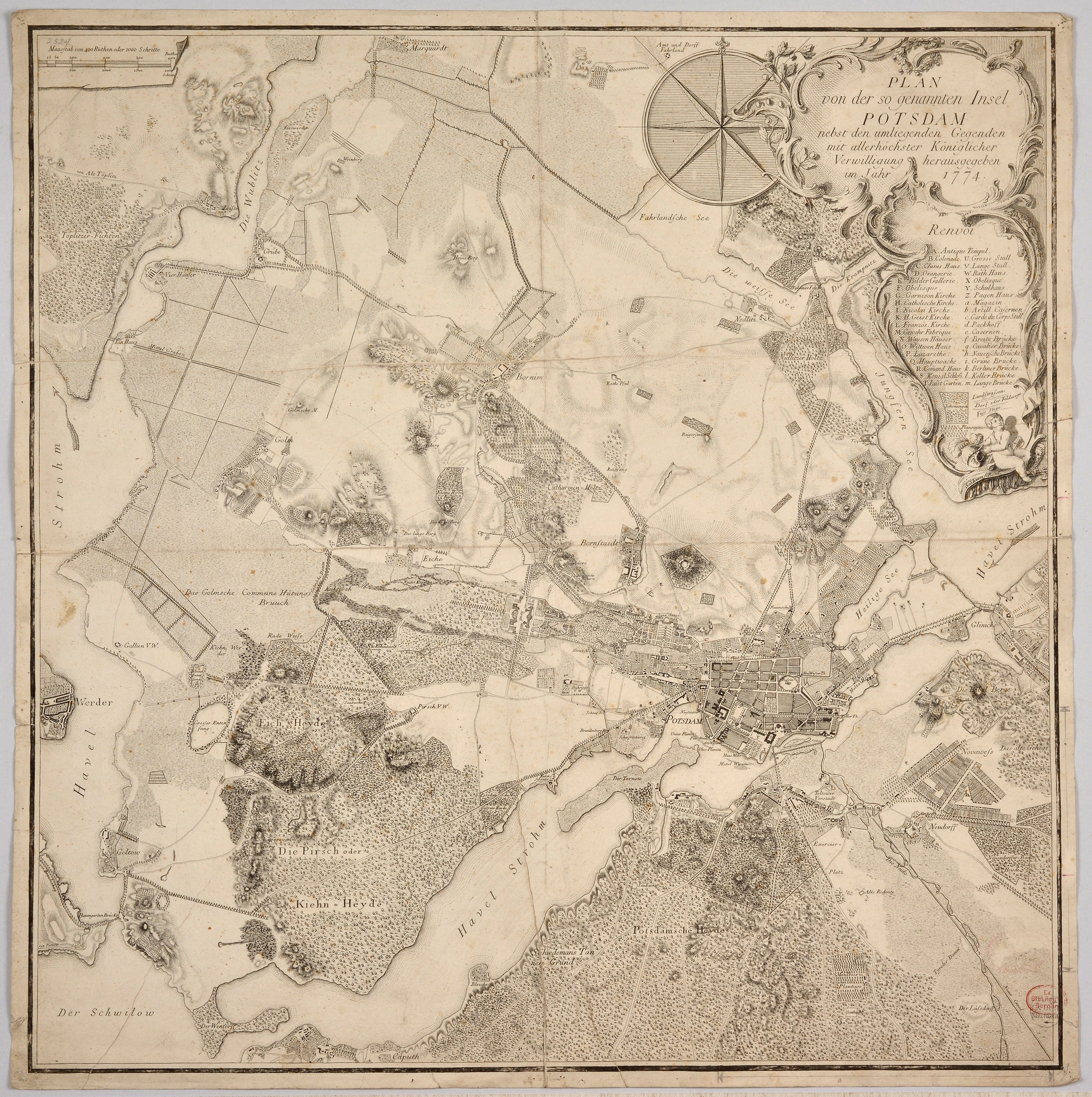
Plan von der sogenannten Insel Potsdam
Vgl. Text zu L-77-5 (Dublette, kaschiert und in Quadrate zerteilt)
bez.:
o. li.: Maasstab von 400 Ruthen oder 2000 Schritte (darüber in Bleistift alte Eingangs-Nr. 2524)
o. re.: Plan / von der so genannten Insel / Potsdam / nebst den umliegenden Gegenden / mit allerhöchster Königlicher / Verwilligung herausgegeben / im Jahr 1774. / Renvoi
A. Antique Tempel.
B. Colonade.
C. Chines. Haus.
D. Orangerie.
E. Bilder Gallerie.
F. Obelisque
G. Garnison Kirche
H. Catholische Kirche
I. Nicolai Kirche
K. H. Geist Kirche.
L. Französ. Kirche.
M. Gewehr Fabrique.
N. Waisen Häuser.
O. Wittwen Haus.
P. Lazarethe.
Q. Hauptwache.
R. Command. Haus.
S. Königl: Schloss.
T. Lust Garten.
/
U. Grosse Stall.
V. Lange Stall.
W. Rath Haus.
X. Obelisque
Z. Pagen Haus.
a. Magazin.
b. Artill. Casernen.
c. Garde du Corps Stall.
d. Packhoff.
e. Casernen.
f. Breite Brücke.
g. Cavalier Brücke.
h. Nauensche Brücke.
i. Grüne Brücke.
k. Berliner Brücke.
l. Keller Brücke.
m. Lange Brücke.
/
[Symbole für:] Schonungen, Landstraßen, Dorf- oder Feldwege, Fußstege
Schleuen fc. Berol.
u. re.: Stempel Ex. Bibl. Reg. Berolina
(Object from: Potsdam Museum - Forum für Kunst und Geschichte Original entry)
Material /Technique ...
Radierung
Measurements ...
65 x 64,4 cm (Blattmaß)
[Relationship to location] ...
New Palace (Potsdam)
[Relationship to location] ...
New Palace (Potsdam)
[Relationship to location] ...
Sanssouci
[Relationship to location] ...
Potsdam